Monday, May 29, 2006

More popcorn showers this afternoon

NWS radar is showing scattered showers in NE MS, north of Dyersburg, and in the MO Bootheel this afternoon. These are moving N at 10-15 mph (according to the NWS). Most of the storms will dump less than .5 in/hour, but some could dump over 1 in/hour. Some of the storms are strong with max hail sizes in the .75-1 in range. Max echo tops are 47200 kft.

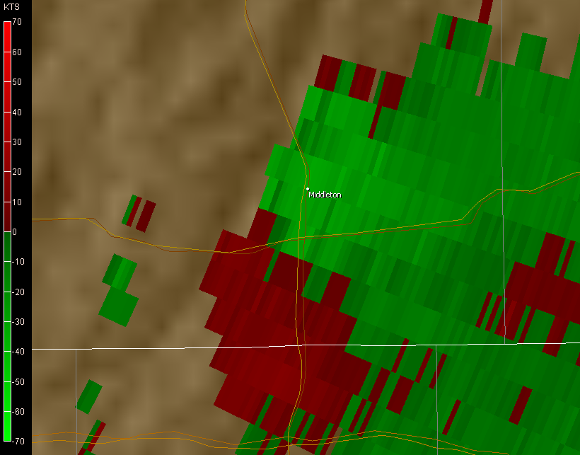
One concern I have right now is a cell that is moving into Hardeman/McNairy Counties from MS. At 5:15, there seemed to be an area of possible rotation right over the town of Middleton. I will be watching this one closely. Also getting some high cloud tops with this one - 48900 kft. VIL is at 51 & max hail size is 1.12 in. I would not be surprised to see a warning out for this one soon.

No comments:

Syndication


[What is this?]

NEW: Simply click on the link below to add this content to anything you could possibly imagine.

Add to any service

Legal Information

© 2005-2007 by Jake Hughes. Some rights reserved - see below.

Creative Commons License

This work is licensed under a Creative Commons Attribution-Noncommercial-No Derivative Works 2.5 License.

Never base important decisions on this or any weather information obtained from the Internet.

All other trademarks and copyrighted material not mentioned here are the property of their respective owners.