Again, I'm sorry for not posting in the past few days. The last week and a half has been extremely hectic and busy.
Anyway, Tropical Storm Debby is currently located in the North Central Atlantic, and poses no threat to land in the immediate future. As of 4 PM CDT, maximum sustained winds were up to 50 mph, with higher gusts. It was moving toward the WNW at 20 mph. In the coming days, Debby is expected to curve toward the north, thus avoiding all land.
Though Debby will (likely) not harm land, the newly formed Tropical Depression Five might. As of 4 PM CDT, TD 5 was located 155 miles SW of Martinque. It was moving toward the west at 22 mph. Max sustained winds were 35 mph, and the winds are expected to strengthen to tropical storm status in the immediate future. As of right now, TD 5 is not headed for any land, but rain/wind bands could affect the Windward Islands, and Trindad and Tobago.
Use the links above for the latest information direct from the National Hurricane Center and the National Weather Service.
Thursday, August 24, 2006
Friday, August 18, 2006
First case of West Nile reported in Shelby County
According to a press release from the TN Department of Health, the first case of the West Nile Virus in Tennessee has been reported right here in Shelby County. According to the release, "the patient (who according to WREG's story, is over 50) is hospitalized and expected to make a full recovery." WREG says that the victim first realized something was wrong when they started having headaches and memory loss.
Here are a few reminders from the Dept. of Health on how to protect yourself from this disease:
Here are a few reminders from the Dept. of Health on how to protect yourself from this disease:
- Use a mosquito repellent containing DEET, Picaridin or oil of lemon eucalyptus whenever outdoors. Even spending a short time outdoors can be long enough to get a mosquito bite. Follow use instructions on the product.
- Wearing the right clothing can help reduce mosquito bites. When possible, wear long-sleeves, long pants and socks when outdoors.
- Be aware of peak mosquito hours. Peak mosquito biting times are between dusk and dawn for many species of mosquitoes.
- Limit the number of places around your home for mosquitoes to breed by getting rid of items that collect water, including toys, bird baths, old tires, buckets and other items that might hold standing water.
- Make sure doors and windows are screened if you keep them open and repair any damage to screens.
Monday, August 14, 2006
Severe weather rolling through this evening
UPDATE #5: SVR just issued for Chester Co until 11 PM. I'm going to bed now. Good night, everyone.
UPDATE #4 (9:50 PM): SVR for Fayette Co is cancelled, Hardeman's warning still continues. Significant Weather Advisory was just issued for Madison Co; this storm could become severe soon. Watch this one.
UPDATE #3 (9:37 PM): Severe T'storm Watch is cancelled.
UPDATE #2 (9:32 PM): SVR just issued for Fayette and Hardeman Counties until 10:15. Also, the SPC has cleared out all of the counties in the Severe T'storm Watch except for the MEG counties (expires at 10 PM CDT). I wonder if a new watch will be issued soon? Probably not - thanks to the loss of daytime heating, we have lost a lot of the energy in these storms, so they will likely weaken. But, some redevelopment is possible. Just have to wait and see.
UPDATE (8:59 PM): LSRs issued a few minutes ago...here's what it said:
ORIGINAL POST (7:59 PM): Lots to talk about, so little time...
There is a Severe Thunderstorm Watch in effect for the MEG counties of Dyer, Lake, Obion, Dunklin, Pemiscot, Greene, Mississippi, Craighead, Poinsett, Clay, Randolph, and Lawrence until 10 PM CDT.
Additionally, there are Severe Thunderstorm Warnings in effect for Mississippi Co. (until 8:30 PM), Greene and Clay Co. (8:15 PM), Dunklin (8:15 PM), and Pemiscot (8:45 PM). Refer to local media or the NWS website for the latest.
Stay with us for the latest.
UPDATE #4 (9:50 PM): SVR for Fayette Co is cancelled, Hardeman's warning still continues. Significant Weather Advisory was just issued for Madison Co; this storm could become severe soon. Watch this one.
UPDATE #3 (9:37 PM): Severe T'storm Watch is cancelled.
UPDATE #2 (9:32 PM): SVR just issued for Fayette and Hardeman Counties until 10:15. Also, the SPC has cleared out all of the counties in the Severe T'storm Watch except for the MEG counties (expires at 10 PM CDT). I wonder if a new watch will be issued soon? Probably not - thanks to the loss of daytime heating, we have lost a lot of the energy in these storms, so they will likely weaken. But, some redevelopment is possible. Just have to wait and see.
UPDATE (8:59 PM): LSRs issued a few minutes ago...here's what it said:
(20:51:21) iembot: 4 S Annieville [Lawrence Co, AR] fire dept/rescue reports TSTM WND DMG at 05:47 PM CDT -- trees down
(20:51:21) iembot: Bono [Craighead Co, AR] broadcast media reports TSTM WND DMG at 06:20 PM CDT -- roof damage to home and cars blown off road
(20:51:21) iembot: Jonesboro [Craighead Co, AR] law enforcement reports TSTM WND DMG at 06:50 PM CDT -- trees down along hwy 141
(20:51:22) iembot: Corning [Clay Co, AR] trained spotter reports TSTM WND GST of E65.00 MPH at 07:10 PM CDT -- estimated wind gusts 65 to 70 mph
(20:51:22) iembot: Trumann [Poinsett Co, AR] law enforcement reports HAIL of penny size (E0.75 INCH) at 07:36 PM CDT --
(20:51:22) iembot: Harrisburg [Poinsett Co, AR] law enforcement reports TSTM WND DMG at 07:58 PM CDT -- trees down on hwy 163
(20:51:22) iembot: Joiner [Mississippi Co, AR] fire dept/rescue reports TSTM WND GST of E60.00 MPH at 08:00 PM CDT --
(20:51:22) iembot: Harrisburg [Poinsett Co, AR] law enforcement reports TSTM WND DMG at 08:00 PM CDT -- powerlines down on rayburn road
(20:51:22) iembot: Keiser [Mississippi Co, AR] nws employee reports TSTM WND GST of E60.00 MPH at 08:10 PM CDT --
ORIGINAL POST (7:59 PM): Lots to talk about, so little time...
There is a Severe Thunderstorm Watch in effect for the MEG counties of Dyer, Lake, Obion, Dunklin, Pemiscot, Greene, Mississippi, Craighead, Poinsett, Clay, Randolph, and Lawrence until 10 PM CDT.
Additionally, there are Severe Thunderstorm Warnings in effect for Mississippi Co. (until 8:30 PM), Greene and Clay Co. (8:15 PM), Dunklin (8:15 PM), and Pemiscot (8:45 PM). Refer to local media or the NWS website for the latest.
Stay with us for the latest.
Saturday, August 12, 2006
Working on major changes for blog!
Howdy everyone...sorry I haven't posted recently.
This morning, as I lay in bed, I got a brilliant idea to incorporate live weather data into this blog. So, 12 hours later, after spending about 10 at the computer, I have a little work to show for it.
Some people around here may have heard of HamWeather, a great thing for websites to add for weather info. Plus, it's ABSOLUTELY FREE!!!!!!!!! I have been working on this, and hope to have it up and running before the end of the coming week.
You can see my work so far by clicking here. Do remember, however, that this software is in the alpha stages, so a lot of it doesn't work (especially the images). If you know of any obvious bugs, please post about it here.
Sunday, August 06, 2006
Heat Advisory in effect today and Monday
The NWS has issued yet another Heat Advisory for all of North MS, Shelby County, and the following counties in AR: Crittenden, Cross, St. Francis, Lee, and Phillips. This advisory is in effect until 7 PM Monday.
Additionally, a Code Orange ozone air forecast is in effect today. This means that "active children and adults, and people with lung disease, such as asthma, should reduce prolonged or heavy exertion outdoors." (Airnow.gov)
Please take many water breaks if you have to be outside and stay cool if you are indoors. Refer to previous posts about what to do during a heat wave.
Tuesday, August 01, 2006
Tropical Storm Chris poses a threat
I have been watching this system for a while (at least 5 days). I have seen the NHC say that it was possible that it could form, then say that it was unlikely to form, and then watch them declare it a tropical depression. All along, I secretely thought that this may become something big. And, it is slowly becoming that way. At 5 PM AST, the NHC put out an advisory saying that Chris had maximum sustained winds of 45 mph. Five minutes later, they put out an update saying that based on recon data, "the maximum sustained winds in Chris have increased to near 60 mph" and that a special advisory reflecting these changes would be released. Keep an eye out for this storm.
Monday, July 31, 2006
Great blog on Middle TN weather
Hey everyone! Go and check out the new, handy-dandy Southern Tennessee Weather Blog! This blog was just created today by one of my friends from the TN WX Zone forum, and I am sure it will have some great weather info from that area. The counties covered in that blog are: Marshall, Maury, Giles, Bedford, Lawrence, Lincoln, Moore, Franklin, Wayne, Coffee, Perry, and Lewis (all in TN). Be sure to stop by!
The address is http://southerntnwx.blogspot.com/.
The address is http://southerntnwx.blogspot.com/.
Sunday, July 30, 2006
Heat Advisory extended until Tuesday
The Heat Advisory that was in effect has been extended until 7 PM Tuesday. According to the notice, actual high temperatures on Monday and Tuesday will be in the mid-upper 90s. With the high humidities we will have this week, heat indices will be 105-110 degrees. Once again, here are some heat safety tips from the Red Cross:
- Slow down. Avoid strenuous activity. If you must do strenuous activity, do it during the coolest part of the day, which is usually in the morning between 4:00 a.m. and 7:00 a.m.
- Stay indoors as much as possible. If air conditioning is not available, stay on the lowest floor, out of the sunshine. Try to go to a public building with air conditioning each day for several hours. Remember, electric fans do not cool the air, but they do help sweat evaporate, which cools your body.
- Wear lightweight, light-colored clothing. Light colors will reflect away some of the sun's energy.
- Drink plenty of water regularly and often. Your body needs water to keep cool.
- Drink plenty of fluids even if you do not feel thirsty.
- Water is the safest liquid to drink during heat emergencies. Avoid drinks with alcohol or caffeine in them. They can make you feel good briefly, but make the heat's effects on your body worse. This is especially true about beer, which dehydrates the body.
- Eat small meals and eat more often. Avoid foods that are high in protein, which increase metabolic heat.
- Avoid using salt tablets unless directed to do so by a physician.
- Heat cramps: Heat cramps are muscular pains and spasms due to heavy exertion. Although heat cramps are the least severe, they are an early signal that the body is having trouble with the heat.
- Heat exhaustion: Cool, moist, pale, or flushed skin; heavy sweating; headache; nausea or vomiting; dizziness; and exhaustion. Body temperature will be near normal.
- Heat stroke: Hot, red skin; changes in consciousness; rapid, weak pulse; and rapid, shallow breathing. Body temperature can be very high-- as high as 105 degrees F. If the person was sweating from heavy work or exercise, skin may be wet; otherwise, it will feel dry.
- Heat cramps: Get the person to a cooler place and have him or her rest in a comfortable position. Lightly stretch the affected muscle and replenish fluids. Give a half glass of cool water every 15 minutes. Do not give liquids with alcohol or caffeine in them, as they can make conditions worse.
- Heat exhaustion: Get the person out of the heat and into a cooler place. Remove or loosen tight clothing and apply cool, wet cloths, such as towels or sheets. If the person is conscious, give cool water to drink. Make sure the person drinks slowly. Give a half glass of cool water every 15 minutes. Do not give liquids that contain alcohol or caffeine. Let the victim rest in a comfortable position, and watch carefully for changes in his or her condition.
- Heat stroke: Heat stroke is a life-threatening situation. Help is needed fast. Call 9-1-1 or your local emergency number. Move the person to a cooler place. Quickly cool the body. Immerse victim in a cool bath, or wrap wet sheets around the body and fan it. Watch for signals of breathing problems. Keep the person lying down and continue to cool the body any way you can. If the victim refuses water or is vomiting or there are changes in the level of consciousness, do not give anything to eat or drink.
Heat Advisory in effect today
The NWS in Memphis has issued a Heat Advisory for the entire Mid-South today. It is in effect from 11 AM - 7 PM. Heat indices could reach 110 today. Please take the proper precautions and limit your outdoor activity.
Saturday, July 29, 2006
Flooding reeks havoc on Tennessee this afternoon
You probably weren't aware, but it rained in the northwestern portion of the Memphis CWA today. And it rained a lot. Radar estimates show almost 8" of rain over that area, and that is probably under the real amount. Now, before Noah opens his ark, let me tell you about some of the incidents in our area.
- Near Clarksburg, TN (12:35 PM): Many county roads flooded
- Chesterfield, TN (12:39 PM): Caramel Cove Road flooded
- Parsons, TN (12:41 PM)
- Four businesses have 4" of flood water
- One home has 6" of water, and another has nearly a foot of water
- Sections of almost every road in town is flooded with almost two feet of water
Wednesday, July 26, 2006
Forum looking for Mid-South members
Hey everyone! TalkWeather, a great weather forum, is looking for more Mid-South members. We already have two people from the local NWS, and a few others (including myself). We would greatly appreciate if you could join.
The address is www.talkweather.com.
The address is www.talkweather.com.
Thursday, July 13, 2006
Heat advisory in effect Friday
The NWS in Memphis has issued a Heat Advisory for the entire Mid-South Friday, from 12:00 PM to 7:00 PM CDT. Heat index values could reach 105 degrees tomorrow with actual highs in the mid-90s. Here are some safety tips on how to deal with hot weather from the Red Cross:
- Slow down. Avoid strenuous activity. If you must do strenuous activity, do it during the coolest part of the day, which is usually in the morning between 4:00 a.m. and 7:00 a.m.
- Stay indoors as much as possible. If air conditioning is not available, stay on the lowest floor, out of the sunshine. Try to go to a public building with air conditioning each day for several hours. Remember, electric fans do not cool the air, but they do help sweat evaporate, which cools your body.
- Wear lightweight, light-colored clothing. Light colors will reflect away some of the sun's energy.
- Drink plenty of water regularly and often. Your body needs water to keep cool.
- Drink plenty of fluids even if you do not feel thirsty.
- Water is the safest liquid to drink during heat emergencies. Avoid drinks with alcohol or caffeine in them. They can make you feel good briefly, but make the heat's effects on your body worse. This is especially true about beer, which dehydrates the body.
- Eat small meals and eat more often. Avoid foods that are high in protein, which increase metabolic heat.
- Avoid using salt tablets unless directed to do so by a physician.
Tuesday, July 11, 2006
Severe weather possible today
According to the NWS and SPC, there is a slight risk of severe weather today in NW Arkansas, the Missouri Bootheel, and extreme NW Tennessee. This shouldn't be a huge outbreak as temperatures will have to be pretty high for storms to fire. The local NWS says that the main threat will be damaging winds. I don't think we will see any severe weather, but if we do, it will be extremely isolated.
Monday, July 10, 2006
Forum just for TN folk!
Yes, boys and girls, there is a forum out in cyberspace dedicated solely to Tennessee Weather! It is called TennesseeWeatherZone and would like more members, especially from our area. The Nashville area is definitely represented, but the Mid-South does not have many members. I am the site moderator at that site, so come on over and discuss local weather! The address is http://www.armleg.com/forum/index.php?mforum=tennesseeweathe (and, no, there is not an "r" at the end of the address). So come on, Western Tennesseans, represent!
Sunday, July 09, 2006
Some WunderBlog entries now archived on MSW
The October and November entries from my old WunderBlog are now stored on this website. To view them, look in the archives under October and November 2005 and look for posts with "- WU" after it. These are the original posts, unedited from their previous state. The other months will be added soon.
Scattered thunderstorms to move through tonight
Right now, according to NWS radar, some very light showers are located across Lake and Obion Counties and slowly moving toward the southeast. Some additional showers will be moving into this area in the next few hours.
According to the Hazardous Weather Outlook issued by the NWS, some scattered thundershowers will push into the Mid-South late tonight and tomorrow. Here is what they said:
According to the Hazardous Weather Outlook issued by the NWS, some scattered thundershowers will push into the Mid-South late tonight and tomorrow. Here is what they said:
A WARM FRONT WILL PUSH INTO THE MID-SOUTH FROM THE SOUTHWEST TONIGHT. MEANWHILE...AN UPPER LEVEL DISTURBANCE WILL APPROACH FROM THE NORTHWEST. SCATTERED TO NUMEROUS SHOWERS AND THUNDERSTORMS ARE EXPECTED TO DEVELOP AHEAD OF THE UPPER LEVEL DISTURBANCE AND SPREAD INTO THE MID-SOUTH LATER TONIGHT. HOWEVER...THE THREAT OF SEVERE WEATHER IS LOW.Additionally, some thundershowers will move throughout the Mid-South tomorrow. The main threat from these storms will be heavy rainfall. These showers should slowly exit the Mid-South Tuesday toward the northeast, so the northern half of the area will be seeing additional rainfall. Wednesday and beyond, summer weather returns to our area with heat index values possibly reaching near 105. Actual highs will be around 97.
Friday, July 07, 2006
New discussion board!
New! I have created a discussion board so that users of this blog may communicate with each other! The address is http://midsouthwx.invisionplus.net. I encourage you to visit it today and sign up (it's free!)
Thursday, July 06, 2006
Parts of Mid-South under burn bans
Due to the recent dry conditions, Clay County, Mississippi is under a burn ban. This means that any outdoor burning is prohibited in this county. During this firework-shooting season, please respect the officials and DO NOT shoot anything. There are no other burn bans in effect at this time in the Mid-South.
Wednesday, June 28, 2006
Some NWRs may go out today
In a PNS issued by the NWS Memphis, the forecasters state that they are performing maintenance on the NOAA Weather Radio systems and, as a result, they may go out for some short periods. This will take place from 9 AM - 4 PM. Additionally, the weekly test of the NWRs will take place tomorrow at its regularly scheduled time, instead of today.
Friday, June 23, 2006
Day Five - Lightning Safety Awareness Week
"Medical Aspects of Lightning"
How Big A Problem Is This? Statistics
Lightning has been the second largest storm killer in the U.S. for the last 40 years, exceeded only by floods. A lightning strike can result in a cardiac arrest (heart stopping) at the time of the injury, although some victims may appear to have a delayed death a few days later if they are resuscitated but have suffered irreversible brain damage.
According to Storm Data, a National Weather Service publication, over the last 30 years the U.S. has averaged 66 reported lightning fatalities per year. Due to under reporting, the figures are more realistically at least 70 deaths per year. Only about 10% of people who are struck by lightning are killed, leaving 90% with various degrees of disability.
| ODDS OF BECOMING A LIGHTNING VICTIM | |
| U.S. 2000 Census population | 280,000,000 |
| Odds of being struck by lightning in a given year (reported deaths + injuries) | 1/700,000 |
| Odds of being struck by lightning in a given year (estimated total deaths + injuries) | 1/400,000 |
| Odds of being struck in your lifetime (Est. 80 years) | 1/5000 |
| Odds you will be affected by someone being struck (Ten people affected for every one struck) | 1/500 |
Who Gets Injured
While about one third of all injuries occur during work, workers compensation companies are often reluctant to acknowledge the injury or pay related medical expenses. About another third of injuries occur during recreational or sports activities. The last third occurs in diverse situation, including injuries to those inside buildings.
How Do Lightning Injuries Affect People?
Lightning tends to be a nervous system injury and may affect the brain, autonomic nervous system and the peripheral nervous system. When the brain is affected, the person often has difficulty with short-term memory, coding new information and accessing old information, multitasking, distractibility, irritability and personality change.
"Patients have difficulty in all areas that require them to analyze more items of information than they can handle simultaneously. They present (appear) as slow because it takes longer for smaller than normal chunks of information to be processed. They present as distractible because they do not have the spare capacity to monitor irrelevant stimuli at the same time as they are attending to the relevant stimulus. They present as forgetful because while they are concentrating on point A, they do not have the processing space to think about point B simultaneously. They present as inattentive because when the amount of information that they are given exceeds their capacities, they cannot take it all in."
Early on, survivors may complain of intense headaches, ringing in the ears, dizziness, nausea, vomiting and other post-concussion types of symptoms. Survivors may also experience difficulty sleeping, sometimes sleeping excessively at first and then only two or three hours at a time. A few may develop seizure-like activity several weeks to months after the injury.
Personality Changes / Self-Isolation
Many lightning victims may suffer personality changes because of frontal lobe damage and become quite irritable and easy to anger. People who wake up after the injury often do not have the ability to express what is wrong with them, may not recognize much, become embarrassed when they cannot carry on a conversation, work at their previous job, or do the activities that they used to handle. As a result, many isolate themselves, withdrawing from church, friends, family and other activities. Friends, family and co-workers who see the same external person, may not understand why the survivor is so different. Friends soon stop coming by or asking them to participate in activities. Families who are not committed to each other break up.
Obviously, depression becomes a big problem for people who have changed so much and lost so much. Suicide is something almost all severely injured people have thought about at one time or another. Occasionally, those who do not have access to medical care or who do not understand what is happening may resort to alcohol and other drugs, particularly those who have previously used these options. Family and friends of the survivor must remain supportive even though it may require an adjustment in their relationship with the survivor. An injury such as this affects the entire family, not just to the person hit.
Fatigue
Survivors often complain of becoming exhausted after only a few hours of work. This may be because tasks they used to do automatically now require intense concentration. Many return to work but find that they cannot do all of the activities required at their job.
Medical Testing
There are two kinds of medical tests:
- Anatomic tests take a simple picture (x-ray) or measurement (blood count)
- Functional tests show how something is working (PET, neuropsychological testing)
Sometimes function can be ascribed to the anatomic tests but often it cannot. The mental changes of a lightning survivor are functional (how the brain works) changes, not anatomic. Anatomic tests such as a CT scan and MRI are usually normal. More functional scans such as PET and SPECT may show changes but are hard to obtain due to their relative infrequency in medical centers. To use an analogy: if an electric shock were sent through a computer, the outside case would probably look OK (similar to a photo or x-rays of the person), the computer boards on the inside would probably look OK and not be fused nor melted (CT, MRI for the person), but when you boot up the computer it would have difficulty accessing files, making calculations, printing, etc. This situation is similar in a person with brain injury who has short-term memory problems, difficulty accessing and coding information, difficulty organizing output, etc.
More useful is a functional test of how a person's brain is working: a neurocognitive or neuropsychological testing. These tests are administered by a neuropsychologist, not by a psychiatrist. The tests consist of a 6-8 hour battery of tests including memory, IQ and organizational ability. Survivors of lightning and electrical injury usually have a characteristic pattern of deficits.
Delayed Problems
Another common, often delayed, problem for some survivors is pain, also difficult to quantify and manage. The pain may not be from chronic intense headaches but may be in the back (perhaps from compression and disc injury from the intense muscle contractions which may throw a person several yards at the time of the injury), or in an extremity. Some may have nerve entrapment syndromes and a small number may eventually develop Sympathetically Mediated Pain Syndrome.
Sometimes the functional tests ordered are testing the wrong thing. An electromyogram (EMG) measures only the motor fibers, which are seldom affected by lightning injury. Smaller pain carrying nerve fibers are not tested by EMG so that a normal EMG means little when ordered for someone with pain. Likewise, the standard EEG primarily measure surface readings of the brain and misses seizure activity in several deeper regions.
Decreased libido and impotence are often reported.
Help Exists - Lightning Strike and Electric Shock Survivors, International, Support Group
An organization of tremendous help to survivors, families, physicians and other professionals is Lightning Strike and Electric Shock Survivors, International (LSESSI), a support group formed in 1989 by a lightning victim. LSESSI has printed materials, offers tremendous support, networks survivors with others in their area, and provides an annual meeting where survivors come together for support and lectures from professionals who work with lightning and electrical survivors and their families. LSESSI can be reached at 910-346-4708, info@lightning-strike.org, or see their Website at http://www.lightning-strike.org/, or at P.O. Box 1156, Jacksonville, NC 28541-1156.
Four Factors Necessary for Recovery
The four most important factors in overcoming disability from lightning injury (or from any illness or major injury for that matter) are:
- Supportive family/friends network.
- Becoming your own advocate and learning as much as you can about this disability.
- A physician willing to listen, read, learn and work with the survivor and their family.
- A sense of humor.
Prevention
Far more important than treating survivors is preventing lightning injury. All of the people who helped make possible National Lightning Safety Awareness Week hope it will help you and your family learn how to avoid injury. Prevention is the KEY.
This factsheet courtesy Dr. Mary Ann Cooper- Associate Professor, Departments of Emergency Medicine and Bioengineering University of Illinois at Chicago
Thursday, June 22, 2006
Day Four - Lightning Safety Awareness Week
What is a Safe Shelter?
A house or other substantial building offers the best protection from lightning. In assessing the safety provided by a particular structure, it is more important to consider what happens if the structure gets struck by lightning, rather than whether the structure will be hit by lightning. For a shelter to provide protection from lightning, it must contain a mechanism for conducting the electrical current from the point of contact to the ground. These mechanisms may be on the outside of the structure, may be contained within the walls of the structure, or may be a combination of the two. On the outside, lightning can travel along the outer shell of the building or may follow metal gutters and downspouts to the ground. Inside a structure, lightning can follow conductors such as the electrical wiring, plumbing, and telephone lines to the ground.
Avoid Unsafe Shelters!
Unless specifically designed to be lightning safe, small structures do little, if anything, to protect occupants from lightning. Many small open shelters on athletic fields, golf courses, parks, roadside picnic areas, schoolyards and elsewhere are designed to protect people from rain and sun, but not lightning. A shelter that does not contain plumbing or wiring throughout, or some other mechanism for grounding from the roof to ground is not safe. Small wooden, vinyl, or metal sheds offer little or no protection from lightning and should be avoided during thunderstorms.
How Lightning Enters a House or Building
There are three main ways lightning enters homes and buildings: (1) a direct strike, (2) through wires or pipes that extend outside the structure, and (3) through the ground. Regardless of the method of entrance, once in a structure, the lightning can travel through the electrical, phone, plumbing, and radio/television reception systems. Lightning can also travel through any metal wires or bars in concrete walls or flooring.
Stay Safe While Inside
Phone use is the leading cause of indoor lightning injuries in the United States. Lightning can travel long distances in both phone and electrical wires, particularly in rural areas. Stay away from windows and doors as these can provide the path for a direct strike to enter a home. Do not lie on the concrete floor of a garage as it likely contains a wire mesh. In general, basements are a safe place to go during thunderstorms. However, there are some things to keep in mind. Avoid contact with concrete walls which may contain metal reinforcing bars. Avoid washers and dryers since they not only have contacts with the plumbing and electrical systems, but also contain an electrical path to the outside through the dryer vent.
Remember Your Pets
You may want to consider the safety of your family pets during thunderstorms. Dog houses are not lightning-safe. Dogs that are chained to trees or chained to wire runners can easily fall victim to a lightning strike.
Protect Your Personal Property
Lightning also causes significant damage to personal property each year. In addition to direct strikes, lightning generates electrical surges that can damage electronic equipment some distance from the actual strike. Typical surge protectors will NOT protect equipment from a lightning strike. To the extent possible, unplug any appliances or electronic equipment from all conductors well before a thunderstorm threatens. This includes not only the electrical system, but also the reception system. If you plan to be away from your home when thunderstorms are possible, be sure to unplug unneeded equipment before you leave.
Summary of Lightning Safety Tips for Inside the Home
- Avoid contact with corded phones
- Avoid contact with electrical equipment or cords. If you plan to unplug any electronic equipment, do so well before the storm arrives.
- Avoid contact with plumbing. Do not wash your hands, do not take a shower, do not wash dishes, and do not do laundry.
- Stay away from windows and doors, and stay off porches.
- Do not lie on concrete floors and do not lean against concrete walls.
Wednesday, June 21, 2006
Day Three - Lightning Safety Awareness Week
"Lightning Safety Outdoors"
This document has two main sections: lightning safety when a safe location is nearby and risk reduction--not safety!--when a safe location is NOT close. No place is absolutely safe from lightning; however, some places are much safer than others. The SAFEST location during lightning activity is a large enclosed building, not a picnic shelter or shed. The second safest location is an enclosed metal vehicle, car, truck, van, etc., but NOT a convertible, bike or other topless or soft top vehicle.
This document has two main sections: lightning safety when a safe location is nearby and risk reduction--not safety!--when a safe location is NOT close. No place is absolutely safe from lightning; however, some places are much safer than others. The SAFEST location during lightning activity is a large enclosed building, not a picnic shelter or shed. The second safest location is an enclosed metal vehicle, car, truck, van, etc., but NOT a convertible, bike or other topless or soft top vehicle.
Safe Buildings
A safe building is one that is fully enclosed with a roof, walls and floor, such as a home, school, office building or a shopping center. Even inside, you should take precautions. Picnic shelters, dugouts, sheds and other partially open or small structures are NOT safe.
Enclosed buildings are safe because of wiring and plumbing. If lightning strikes these types of buildings, or an outside telephone pole, the electrical current from the flash will typically travel through the wiring or the plumbing into the ground. This is why you should stay away from showers, sinks, hot tubs, etc., and electronic equipment such as TVs, radios, and computers.
Lightning can damage or destroy electronics so it's important to have a proper lightning protection system connected to your electronic equipment. The American Meteorological Society has tips for protecting your electronics from lightning.
Unsafe Buildings
Examples of buildings which are unsafe include car ports, covered but open garages, covered patio, picnic shelters, beach shacks/pavilions, golf shelters, camping tents, large outdoor tents, baseball dugouts and other small buildings such as sheds and greeenhouses that do not have electricity or plumbing.
Safe Vehicle
A safe vehicle is a hard-topped car, SUV, minivan, bus, tractor, etc. (soft-topped convertibles are not safe) . If you seek shelter in your vehicle, make sure all doors are closed and windows rolled up. Do not touch any metal surfaces.
If you're driving when a thunderstorm starts, pull off the roadway. A lightning flash hitting the vehicle could startle you and cause temporary blindness, especially at night.
Do not use electronic devices such as HAM radios or cell phones during a thunderstorm. Lightning striking the vehicle, especially the antennas, could cause serious injury if you are talking on the radio or holding the microphone at the time of the flash. Emergency officials such as police officers, firefighters, security officers, etc., should use extreme caution using radio equipment when lightning is in the area.
Your vehicle and its electronics may be damaged if hit by lightning. Vehicles struck by lightning are known to have flat tires the next day. This occurs because the lightning punctures tiny holes in the tires. Vehicles have caught fire after being struck by lightning; however, there is no modern day documented cases of vehicles "exploding" due to a lightning flash.
Bolts from the Blue
There are times when a lightning flash can travel horizontally many miles away from the thunderstorm cloud itself and then strike the ground. These types of lightning flashes are called "Bolts from the Blue" because they seem to come out of a clear blue sky. Although these flashes are rare, they have been known to cause fatalities.
When a Safe Location is Nearby:
- Seek safe shelter when you first hear thunder, see dark threatening clouds developing overhead or lightning. Count the seconds between the time you see lightning and hear the thunder. You should already be in a safe location if that time is less than 30 seconds.
- Stay inside until 30 minutes after you last hear thunder.

Figure: When you hear thunder, run to the nearest large building or a fully enclosed vehicle. You are not safe anywhere outside.
Click here to calculate how far lightning is away from you
Plan Ahead! Your best source of up-to-date weather information is a NOAA Weather Radio (NWR). Portable weather radios are handy for outdoor activities. If you don't have NWR, stay up to date via internet, TV, local radio or cell phone. If you are in a group, make sure all leaders or members of the group have a lightning safety plan and are ready to use it.Determine how far you are from a safe enclosed building or a safe vehicle. As soon as you hear thunder, see lightning or see dark threatening clouds, get to a safe location. Then wait 30 minutes after the last rumble of thunder before you leave the safe location. If you are part of a group, particularly a large one, you will need more time to get all group members to safety. NWS recommends having professional lightning detection equipment so your group can be alerted from significant distances from the event site.
When groups are involved, the time needed to get to safety increases. So you need to start leaving sooner. Your entire group should already be in a safe location when the approaching storm reaches within 5 miles from your location.
Here some two common scenarios with suggestions on how to safely respond.
Coach of Outdoor Sports Team
You are a manager of a little league team and have a game this evening at the local recreational park. The weather forecast for the day calls for a partly cloudy skies, with a chance of thunderstorms by early evening. You arrive in your vehicle while the kids arrive with their parents. Once arriving at the park, you notice the only buildings are the the restrooms, an enclosed building. Shortly after sunset, the skies start to cloud up and you see bright flashes in the sky to the west. The local radio station mentions storms are on the way.
In this case, the safest locations are the vehicles the kids came in or the rest rooms. You should have a choice of allowing the kids to go back to their vehicles or bring everyone into the restrooms. It is important NOT to stay in the dugouts as they are not safe place during lightning activity. Once at a safe place, wait 30 minutes after the last rumble of thunder before going back outside.
Family at the Beach
You plan to go to the beach or lake later this morning with the kids. The weather forecast calls for a nice morning followed by a 30 percent chance of afternoon thunderstorms. You decide to head for the beach in your minivan. The beach is about 5 minutes from the parking lot. The only nearby buildings are picnic shelters. By early afternoon you notice the skies darkening and hear distant thunder. What would be your lightning safety plan of action?
In this case, the best place to go is your car. Do NOT seek shelter under the beach picnic shacks because these are not safe in lightning storms. Wait 30 minutes until after the last thunder crack before going back to the beach or driving home.
Camping
You and your family are camping. As you and your spouse are preparing dinner on the camp stove, you here rumbles of thunder in the distance. You look around and you see your tent is nearby, and a large picnic shelter is just down the trail. Your car is about ¼ of a mile away parked at the trailhead. What should you and your family do?
In this case, the smartest thing to do is to round up your family and get into your car. The tent is not a safe place to be as it offers NO protection from a lighting flash. The picnic shelter is also not a safe location. (Both the tent and picnic shelter will keep you dry…but they offer NO protection from a lightning flash). It is best to remain in your vehicle for about 30 minutes after the last rumble of thunder is heard.
When a Safe Location Is Not Nearby
The lightning safety community reminds you that there is NO safe place to be outside in a thunderstorm. If you absolutely can't get to safety, this section is designed to help you lessen the threat of being struck by lightning while outside. Don't kid yourself--you are NOT safe outside.
Being stranded outdoors when lightning is striking nearby is a harrowing experience. Your first and only truly safe choice is to get to a safe building or vehicle. If you are camping, climbing, on a motorcycle or bicycle, boating, scuba diving, or enjoying other outdoor activities and cannot get to a safe vehicle or shelter, follow these last resort tips. These will not prevent you from being hit, just slightly lesson the odds.
- Do NOT seek shelter under tall isolated trees. The tree may help you stay dry but will significantly increase your risk of being struck by lightning. Rain will not kill you, but the lightning can!
- Do NOT seek shelter under partially enclosed buildings
- Stay away from tall, isolated objects. Lightning typically strikes the tallest object. That may be you in an open field or clearing.
- Know the weather patterns of the area. For example, in mountainous areas, thunderstorms typically develop in the early afternoon, so plan to hike early in the day and be down the mountain by noon.
- Know the weather forecast. If there is a high chance of thunderstorms, curtail your outdoor activities.
- Do not place your campsite in an open field on the top of a hill or on a ridge top. Keep your site away from tall isolated trees or other tall objects. If you are in a forest, stay near a lower stand of trees. If you are camping in an open area, set up camp in a valley, ravine, or other low area. A tent offers NO protection from lighting.
- Wet ropes can make excellent conductors. This is BAD news when it comes to lightning activity. If you are mountain climbing and see lightning, and can do so safely, remove unnecessary ropes extended or attached to you. If a rope is extended across a mountain face and lightning makes contact with it, the electrical current will likely travel along the rope, especially if it is wet.
- Stay away from metal objects, such as fences, poles and backpacks. Metal is an excellent conductor. The current from a lightning flash will easily travel for long distances (See Figure 1)

Figure: Dead cows lined up along a metallic fence. Lightning struck the fence, and the current traveled along the fence killing the cows. Photo Courtesy Ruth Lyon-Bateman
If lightning is in the immediate area, and there is no safe location nearby, stay a little aparts from other members of your group so the lightning won't travel between you if hit. Keep your feet together and sit on the ground out in the open. If you can possible run to a vehicle or building, DO so. It is much safer than sitting on the ground.
Motorcyclist/Bicyclist: So has anyone been hit riding a bike? Here are just a few real examples from the last few years.
- Virginia Beach, VA: Motorcyclist killed while traveling on Route 58.
- Altoona, PA: One motorcycle rider killed and three riders injured when they took shelter in a woods from a thunderstorm.
- Wyoming: Motorcyclist injured while driving home on I-90 from Sturgis.
- Taylor Park, CO: Dirt biker injured while heading down mountain pass.
Protect Yourself when on a bicycle, motorcycle or dirt bike.
- Carry a portable Weather Radio or listen to commercial radio.
- If you see threatening skies in the distance and you are passing a safe location, pull over and wait 30 minutes after the last thunder crack.
- If you can turn around and get away from the storm, do so!
- DO NOT ride into a lighting storm!
If you absolutely cannot get to a safe building or vehicle, here are some last resort choices:
- Wait out the storm below an overpass. DO NOT touch steel girders. Move away from your bike. Remain on dry surfaces if possible. Overpasses are engineered structures and are likely to be properly grounded. Although an overpass is likely to be higher than the surrounding landscape, if it is struck by lightning, the electrical current will likely be channeled safely into the ground.
- Look for a bridge. Stay away from water. Stay away from any metal surfaces. Be alert for rapidly rising water if under a bridge.
- High tension wires: If high voltage electrical tension wires cross the road, you may want to seek shelter directly underneath these wires. Do not get too close to the large metal towers which hold up these wires. Stay at least 50 feet away. Electric companies design these high tension wires for lightning strikes. If lighting should strike the wires or towers, the current is designed to safely go deep into the ground.
- If you are caught in the open and lightning is occurring within 5 miles, STOP riding, get off of your motorcycle/bicycle, find a ditch or other low spot and sit down.
- Motorcyclists should move at least 50 feet away from their bike. Bicyclist should lay their bikes on the ground.
IMPORTANT: These recommendations are a last resort. You are NOT safe in these places just marginally safer than in the open.
Click here to read a story about a motorcyclist killed while riding in lightning.
On the Water
The vast majority of lightning injuries and deaths on boats occur on small boats with NO cabin. It is crucial to listen to the weather on a small aquatic vessel without a cabin. If thunderstorms are forecast, don't go out. If you are out on the water and skies are threatening, get back to land and find a safe building or vehicle.
Boats with cabins offer a safer but not perfect environment. Safety is increased further if the boat has a properly installed lightning protection system. If you are inside the cabin, stay away from metal and all electrical components. STAY OFF THE RADIO UNLESS IT IS AN ABSOLUTE EMERGENCY!
What should you do if you are on a small vessel and lightning becomes a threat? If the vessel has an anchor, then you should properly anchor the boat then get as low as possible.
Large boats with cabins, especially those with lightning protection systems properly installed or metal marine vessels are relatively safe. Remember to stay inside the cabin and away from any metal surfaces.
Scuba Divers
If the boat you are in does not have a safe cabin to be in during lightning activity, then you are safer diving deep into the water for the duration of the storm or as long as possible. Your first choice is to head in and get in safe building or vehicle.
Tuesday, June 20, 2006
Day Two - Lightning Safety Awareness Week
"Why do some clouds produce lightning and not others?"
How Powerful is Lightning?
Each spark of lightning can reach over five miles in length, soar to temperatures of approximately 50,000 degrees Fahrenheit, and contain 100 million electrical volts.Lightning Is A Random, Chaotic And Dangerous Fact Of Nature
At any given moment, there are 1,800 thunderstorms in progress somewhere on the earth. This amounts to 16 million storms each year! Scientists that study lightning have a better understanding today of the process that produces lightning, but there is still more to learn about the role of solar flares on the upper atmosphere, the earth's electromagnetic field, and ice in storms. We know the cloud conditions needed to produce lightning, but cannot forecast the location or time of the next stroke of lightning. There are lightning detection systems in the United States and they monitor an average of 25 million flashes of lightning from the cloud to ground every year!
Lightning has been seen in volcanic eruptions, extremely intense forest fires, surface nuclear detonations, heavy snowstorms, and in large hurricanes, however, it is most often seen in thunderstorms. A thunderstorm forms in air that has three components: moisture, instability and something such as a cold front to cause the air to rise. Continued rising motions within the storm may build the cloud to a height of 35,000 to 60,000 feet (6 to 10 miles) above sea level. Temperatures higher in the atmosphere are colder; ice forms in the higher parts of the cloud.
Ice In The Cloud Is Critical To The Lightning Process
Ice in a cloud seems to be a key element in the development of lightning. Storms that fail to produce quantities of ice may also fail to produce lightning. In a storm, the ice particles vary in size from small ice crystals to larger hailstones, but in the rising and sinking motions within the storm there are a lot of collisions between the particles. This causes a separation of electrical charges. Positively charged ice crystals rise to the top of the thunderstorm, and negatively charged ice particles and hailstones drop to the middle and lower parts of the storm. Enormous charge differences (electrical differential) develops.
How Lightning Develops Between The Cloud And The Ground
A moving thunderstorm gathers another pool of positively charged particles along the ground that travel with the storm. As the differences in charges continue to increase, positively charged particles rise up taller objects such as trees, houses, and telephone poles. Have you ever been under a storm and had your hair stand up? Yes, the particles also can move up you! This is one of nature's warning signs that says you are in the wrong place, and you may be a lightning target!
The negatively charged area in the storm will send out a charge toward the ground called a stepped leader. It is invisible to the human eye, and moves in steps in less than a second toward the ground. When it gets close to the ground, it is attracted by all these positively charged objects, and a channel develops. You see the electrical transfer in this channel as lightning. There may be several return strokes of electricity within the established channel that you will see as flickering lightning.
Thunder
The lightning channel heats rapidly to 50,000 degrees. The rapid expansion of heated air causes the thunder. Since light travels faster than sound in the atmosphere, the sound will be heard after the lightning. If you see lightning and hear thunder at the same time, that lightning is in your neighborhood!
Negative Lightning And Positive Lightning
Not all lightning forms in the negatively charged area low in the thunderstorm cloud. Some lightning originates in the cirrus anvil at the top of the thunderstorm. This area carries a large positive charge. Lightning from this area is called positive lightning. This type is particularly dangerous for several reasons. It frequently strikes away from the rain core, either ahead or behind the thunderstorm. It can strike as far as 5 or 10 miles from the storm, in areas that most people do not consider to be a lightning risk area. The other problem with positive lightning is it typically has a longer duration, so fires are more easily ignited. Positive lightning usually carries a high peak electrical current, which increases the lightning risk to an individual.
For more on the science of lightning, see the NOAA National Severe Storms Laboratory.
Monday, June 19, 2006
Day One - Lightning Safety Awareness Week
Today is the first day of Lightning Safety Awareness Week. There is a video available for Day One, located here. You need RealPlayer to view it. Here is the first factsheet from the NWS (unedited).
Lightning—The Underrated Killer
In the United States, there are an estimated 25 million cloud-to-ground lightning flashes each year. Lightning can be fascinating to watch, but it is also extremely dangerous. During the past 30 years, lightning killed an average of 67 people per year in the United States based on documented cases. This is more than the average of 65 deaths per year caused by tornadoes and the average of 16 deaths per year caused by hurricanes. However, because lightning usually claims only one or two victims at a time, and because lightning does not cause the mass destruction left in the wake of tornadoes or hurricanes, lightning generally receives much less attention than the more destructive weather-related killers. While documented lightning injuries in the United States average about 300 per year, undocumented injuries caused by lightning are likely much higher.
Lightning Safety Awareness: Education is Key
Few people really understand the dangers of lightning. Many people don't act promptly to protect their lives, property and the lives of others because they don't understand all the dangers associated with thunderstorms and lightning. The first step in solving this problem is to educate people so that they become aware of the behavior that puts them at risk of being struck by lightning, and to let them know what they can do to reduce that risk. Coaches and other adults who make decisions affecting the safety of children must understand the dangers of lightning.
Watch for Developing Thunderstorms
Thunderstorms are most likely to develop on warm summer days and go through various stages of growth, development and dissipation. On a sunny day, as the sun heats the air, pockets of warmer air start to rise in the atmosphere. When this air reaches a certain level in the atmosphere, cumulus clouds start to form. Continued heating can cause these clouds to grow vertically upward in the atmosphere into "towering cumulus" clouds. These towering cumulus may be one of the first indications of a developing thunderstorm.
The Lightning Discharge: Don't Be a Part of It
During a thunderstorm, each flash of cloud-to-ground lightning is a potential killer. The determining factor on whether a particular flash could be deadly depends on whether a person is in the path of the lightning discharge. In addition to the visible flash that travels through the air, the current associated with the lightning discharge travels along the ground. Although some victims are struck directly by the main lightning stroke, many victims are struck as the current moves in and along the ground. While virtually all people take some protective actions during the most dangerous part of thunderstorms, many leave themselves vulnerable to being struck by lightning as thunderstorms approach, depart, or are nearby.
An Approaching Thunderstorm: When to Seek Safe Shelter
Lightning can strike as far as 10 miles away from the rain area in a thunderstorm. That's about the distance you can hear thunder. When a storm is 10 miles away, it may even be difficult to tell a storm is coming.
IF YOU CAN HEAR THUNDER, YOU ARE WITHIN STRIKING DISTANCE. SEEK SAFE SHELTER IMMEDIATELY!
The first stroke of lightning is just as deadly as the last. If the sky looks threatening, take shelter before hearing thunder.
The 30-30 Rule
Use the 30-30 rule where visibility is good and there is nothing obstructing your view of the thunderstorm. When you see lightning, count the time until you hear thunder. If that time is 30 seconds or less, the thunderstorm is within 6 miles of you and is dangerous. Seek shelter immediately. The threat of lightning continues for much longer period than most people realize. Wait at least 30 minutes after the last clap of thunder before leaving shelter. Don't be fooled by sunshine or blue sky!
If it is cloudy or objects are obscuring your vision, get inside immediately. It is always safer to take precautions than to wait.
Outdoor Activities: Minimize the Risk of Being Struck
Most lightning deaths and injuries in the United States occur during the summer months when the combination of lightning and outdoor summertime activities reaches a peak. During the summer, people take advantage of the warm weather to enjoy a multitude of outdoor recreational activities. Unfortunately, those outdoor recreational activities can put them at greater risk of being struck by lightning. People involved in activities such as boating, swimming, fishing, bicycling, golfing, jogging, walking, hiking, camping, or working out of doors all need to take the appropriate actions in a timely manner when thunderstorms approach. Where organized sports activities take place, coaches, umpires, referees, or camp counselors must protect the safety of the participants by stopping the activities sooner, so that the participants and spectators can get to a safe place before the lightning threat becomes significant. To reduce the threat of death or injury, those in charge of organized outdoor activities should develop and follow a plan to keep participants and spectators safe from lightning.
Indoor Activities: Things to Avoid
Inside homes, people must also avoid activities which put their lives at risk from a possible lightning strike. As with the outdoor activities, these activities should be avoided before, during, and after storms. In particular, people should stay away from windows and doors and avoid contact with anything that conducts electricity. People may also want to take certain actions well before the storm to protect property within their homes, such as electronic equipment.
Helping a Lightning Strike Victim
If a person is struck by lightning, medical care may be needed immediately to save the person's life. Cardiac arrest and irregularities, burns, and nerve damage are common in cases where people are struck by lightning. However, with proper treatment, including CPR if necessary, most victims survive a lightning strike, although the long-term effects on their lives and the lives of family members can be devastating.
Summary
Lightning is a dangerous threat to people in the United States, particularly those outside in the summer. With common sense, we can greatly reduce the number of lightning deaths. When thunderstorms threaten, get to a safe place, stay there longer than you think you need to, stay away from windows and doors and avoid contact with anything that conducts electricity.
Sunday, June 18, 2006
Tornado touchdown near Lakeland, TN yesterday
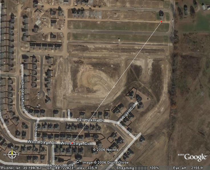 A brief F1 tornado touched down yesterday in the Franklin Farm subdivision near Lakeland, TN. According to a Public Information Statement from the NWS in Memphis, the tornado "touched down near Wood Sage Cove ... around 6:35 PM CDT." It then continued across Tall Hickory Drive and lifted back into the air. The path length was 500 yards. Here is one picture (thanks Google Earth) showing the upclose path of this tornado (click for larger version).
In addition to this map, I have also made an image of the track in relation to the Wolfchase Galleria area, for those not familiar with this area (click for larger version; look for white line with red dots).
According to the Local Storm Report, about 20 homes were damaged, and luckily, there were no injuries. However, a few homes had significant roof damage and one SUV had windows blown out of it.
The initial reports of this tornado came from local broadcast media. WPTY has a more detailed story on some damage. Look for more stories on this tornado from the local media in the days to come.
This week is Lightning Safety Awareness Week
Yes, the title says it all. June 18-24, 2006 is the official Lightning Safety Awareness Week from the National Weather Service. Each day this week, we will show you some different aspects of lightning safety, ranging from "The Medical Aspects of Lightning" to "Lightning Safety Outdoors". We will bring you the unedited article from the NWS.
If you want to get a head start on this week, go to http://www.lightningsafety.noaa.gov for all kinds of information on lightning.
If you want to get a head start on this week, go to http://www.lightningsafety.noaa.gov for all kinds of information on lightning.
Slight risk of severe weather today
According to the SPC, most of the Mid-South is under a slight risk for severe weather today. "Locally damaging winds should be the main threat with these storms." Our local NWS office says that the most likely time for this severe weather will be 10 AM-10 PM. They also say that the heavy rain produced by these storms may result in some flash flooding. Then, they end with this note - "Spotter activation may become necessary today into this evening."
I'll do a technical analysis of this situation this afternoon. Stay tuned for more information.
I'll do a technical analysis of this situation this afternoon. Stay tuned for more information.
Saturday, June 17, 2006
Weather station back online
UPDATE: Well, the station has gone offline again. Will look at it again tomorrow when it is daylight and not raining.
ORIGINAL POST (2:53 PM CDT): Yea! Finally, after a month of downtime, my weather station is back online. You can view the data at Weather Underground, CWOP, or AWEKAS. The links to these websites are on the sidebar at the right.
ORIGINAL POST (2:53 PM CDT): Yea! Finally, after a month of downtime, my weather station is back online. You can view the data at Weather Underground, CWOP, or AWEKAS. The links to these websites are on the sidebar at the right.
Monday, June 12, 2006
TS Alberto Links
As Alberto bears down on the Florida panhandle, I figured I'd create a link directory of related links. I do not warrant any of the info contained on these pages nor do I warrant it. If any of these links have objectionable content on them, please post a comment and I will remove it.
National Hurricane Center Info
Homepage
Latest Public Advisory
3 Day Forecast Map
Weather Underground
Tropical Homepage
Tracking Map
Computer Models
Alberto Radar
Tampa Television
WTVT - 13 (FOX)
WFLA - 8 (NBC) [WeatherPlus Live Stream]
WTSP - 10 (CBS) [Live Radar Stream]
WFTS - 28 (ABC)
Tallahassee Television
WCTV - 6 (CBS)
WTWC - 40 (NBC)
WTXL (under construction)
Orlando Television
WESH - 2 (NBC) [WeatherPlus Live Stream]
WKMG - 6 (CBS)
WFTV - 9 (ABC)
WOFL - 35 (FOX)
Florida Government Information
Florida EMA
Shelter Info
If you have any links to add, please post a comment and I will add it!
Subscribe to:
Posts (Atom)
Syndication
[What is this?]
NEW: Simply click on the link below to add this content to anything you could possibly imagine.
Legal Information
© 2005-2007 by Jake Hughes. Some rights reserved - see below.

This work is licensed under a Creative Commons Attribution-Noncommercial-No Derivative Works 2.5 License.
Never base important decisions on this or any weather information obtained from the Internet.All other trademarks and copyrighted material not mentioned here are the property of their respective owners.
