Tuesday, June 20, 2006

Day Two - Lightning Safety Awareness Week

"Why do some clouds produce lightning and not others?"

How Powerful is Lightning?

Each spark of lightning can reach over five miles in length, soar to temperatures of approximately 50,000 degrees Fahrenheit, and contain 100 million electrical volts.

Lightning Is A Random, Chaotic And Dangerous Fact Of Nature

At any given moment, there are 1,800 thunderstorms in progress somewhere on the earth. This amounts to 16 million storms each year! Scientists that study lightning have a better understanding today of the process that produces lightning, but there is still more to learn about the role of solar flares on the upper atmosphere, the earth's electromagnetic field, and ice in storms. We know the cloud conditions needed to produce lightning, but cannot forecast the location or time of the next stroke of lightning. There are lightning detection systems in the United States and they monitor an average of 25 million flashes of lightning from the cloud to ground every year!

Lightning has been seen in volcanic eruptions, extremely intense forest fires, surface nuclear detonations, heavy snowstorms, and in large hurricanes, however, it is most often seen in thunderstorms. A thunderstorm forms in air that has three components: moisture, instability and something such as a cold front to cause the air to rise. Continued rising motions within the storm may build the cloud to a height of 35,000 to 60,000 feet (6 to 10 miles) above sea level. Temperatures higher in the atmosphere are colder; ice forms in the higher parts of the cloud.

Ice In The Cloud Is Critical To The Lightning Process

Ice in a cloud seems to be a key element in the development of lightning. Storms that fail to produce quantities of ice may also fail to produce lightning. In a storm, the ice particles vary in size from small ice crystals to larger hailstones, but in the rising and sinking motions within the storm there are a lot of collisions between the particles. This causes a separation of electrical charges. Positively charged ice crystals rise to the top of the thunderstorm, and negatively charged ice particles and hailstones drop to the middle and lower parts of the storm. Enormous charge differences (electrical differential) develops.

How Lightning Develops Between The Cloud And The Ground

A moving thunderstorm gathers another pool of positively charged particles along the ground that travel with the storm. As the differences in charges continue to increase, positively charged particles rise up taller objects such as trees, houses, and telephone poles. Have you ever been under a storm and had your hair stand up? Yes, the particles also can move up you! This is one of nature's warning signs that says you are in the wrong place, and you may be a lightning target!

The negatively charged area in the storm will send out a charge toward the ground called a stepped leader. It is invisible to the human eye, and moves in steps in less than a second toward the ground. When it gets close to the ground, it is attracted by all these positively charged objects, and a channel develops. You see the electrical transfer in this channel as lightning. There may be several return strokes of electricity within the established channel that you will see as flickering lightning.

Thunder

The lightning channel heats rapidly to 50,000 degrees. The rapid expansion of heated air causes the thunder. Since light travels faster than sound in the atmosphere, the sound will be heard after the lightning. If you see lightning and hear thunder at the same time, that lightning is in your neighborhood!

Negative Lightning And Positive Lightning

Not all lightning forms in the negatively charged area low in the thunderstorm cloud. Some lightning originates in the cirrus anvil at the top of the thunderstorm. This area carries a large positive charge. Lightning from this area is called positive lightning. This type is particularly dangerous for several reasons. It frequently strikes away from the rain core, either ahead or behind the thunderstorm. It can strike as far as 5 or 10 miles from the storm, in areas that most people do not consider to be a lightning risk area. The other problem with positive lightning is it typically has a longer duration, so fires are more easily ignited. Positive lightning usually carries a high peak electrical current, which increases the lightning risk to an individual.

For more on the science of lightning, see the NOAA National Severe Storms Laboratory.

Monday, June 19, 2006

Day One - Lightning Safety Awareness Week

Today is the first day of Lightning Safety Awareness Week. There is a video available for Day One, located here. You need RealPlayer to view it. Here is the first factsheet from the NWS (unedited).

Lightning—The Underrated Killer

In the United States, there are an estimated 25 million cloud-to-ground lightning flashes each year. Lightning can be fascinating to watch, but it is also extremely dangerous. During the past 30 years, lightning killed an average of 67 people per year in the United States based on documented cases. This is more than the average of 65 deaths per year caused by tornadoes and the average of 16 deaths per year caused by hurricanes. However, because lightning usually claims only one or two victims at a time, and because lightning does not cause the mass destruction left in the wake of tornadoes or hurricanes, lightning generally receives much less attention than the more destructive weather-related killers. While documented lightning injuries in the United States average about 300 per year, undocumented injuries caused by lightning are likely much higher.

Lightning Safety Awareness: Education is Key

Few people really understand the dangers of lightning. Many people don't act promptly to protect their lives, property and the lives of others because they don't understand all the dangers associated with thunderstorms and lightning. The first step in solving this problem is to educate people so that they become aware of the behavior that puts them at risk of being struck by lightning, and to let them know what they can do to reduce that risk. Coaches and other adults who make decisions affecting the safety of children must understand the dangers of lightning.

Watch for Developing Thunderstorms

Thunderstorms are most likely to develop on warm summer days and go through various stages of growth, development and dissipation. On a sunny day, as the sun heats the air, pockets of warmer air start to rise in the atmosphere. When this air reaches a certain level in the atmosphere, cumulus clouds start to form. Continued heating can cause these clouds to grow vertically upward in the atmosphere into "towering cumulus" clouds. These towering cumulus may be one of the first indications of a developing thunderstorm.

The Lightning Discharge: Don't Be a Part of It

During a thunderstorm, each flash of cloud-to-ground lightning is a potential killer. The determining factor on whether a particular flash could be deadly depends on whether a person is in the path of the lightning discharge. In addition to the visible flash that travels through the air, the current associated with the lightning discharge travels along the ground. Although some victims are struck directly by the main lightning stroke, many victims are struck as the current moves in and along the ground. While virtually all people take some protective actions during the most dangerous part of thunderstorms, many leave themselves vulnerable to being struck by lightning as thunderstorms approach, depart, or are nearby.

An Approaching Thunderstorm: When to Seek Safe Shelter

Lightning can strike as far as 10 miles away from the rain area in a thunderstorm. That's about the distance you can hear thunder. When a storm is 10 miles away, it may even be difficult to tell a storm is coming.

IF YOU CAN HEAR THUNDER, YOU ARE WITHIN STRIKING DISTANCE. SEEK SAFE SHELTER IMMEDIATELY!

The first stroke of lightning is just as deadly as the last. If the sky looks threatening, take shelter before hearing thunder.

The 30-30 Rule

Use the 30-30 rule where visibility is good and there is nothing obstructing your view of the thunderstorm. When you see lightning, count the time until you hear thunder. If that time is 30 seconds or less, the thunderstorm is within 6 miles of you and is dangerous. Seek shelter immediately. The threat of lightning continues for much longer period than most people realize. Wait at least 30 minutes after the last clap of thunder before leaving shelter. Don't be fooled by sunshine or blue sky!

If it is cloudy or objects are obscuring your vision, get inside immediately. It is always safer to take precautions than to wait.

Outdoor Activities: Minimize the Risk of Being Struck

Most lightning deaths and injuries in the United States occur during the summer months when the combination of lightning and outdoor summertime activities reaches a peak. During the summer, people take advantage of the warm weather to enjoy a multitude of outdoor recreational activities. Unfortunately, those outdoor recreational activities can put them at greater risk of being struck by lightning. People involved in activities such as boating, swimming, fishing, bicycling, golfing, jogging, walking, hiking, camping, or working out of doors all need to take the appropriate actions in a timely manner when thunderstorms approach. Where organized sports activities take place, coaches, umpires, referees, or camp counselors must protect the safety of the participants by stopping the activities sooner, so that the participants and spectators can get to a safe place before the lightning threat becomes significant. To reduce the threat of death or injury, those in charge of organized outdoor activities should develop and follow a plan to keep participants and spectators safe from lightning.

Indoor Activities: Things to Avoid

Inside homes, people must also avoid activities which put their lives at risk from a possible lightning strike. As with the outdoor activities, these activities should be avoided before, during, and after storms. In particular, people should stay away from windows and doors and avoid contact with anything that conducts electricity. People may also want to take certain actions well before the storm to protect property within their homes, such as electronic equipment.

Helping a Lightning Strike Victim

If a person is struck by lightning, medical care may be needed immediately to save the person's life. Cardiac arrest and irregularities, burns, and nerve damage are common in cases where people are struck by lightning. However, with proper treatment, including CPR if necessary, most victims survive a lightning strike, although the long-term effects on their lives and the lives of family members can be devastating.

Summary

Lightning is a dangerous threat to people in the United States, particularly those outside in the summer. With common sense, we can greatly reduce the number of lightning deaths. When thunderstorms threaten, get to a safe place, stay there longer than you think you need to, stay away from windows and doors and avoid contact with anything that conducts electricity.

Sunday, June 18, 2006

Tornado touchdown near Lakeland, TN yesterday

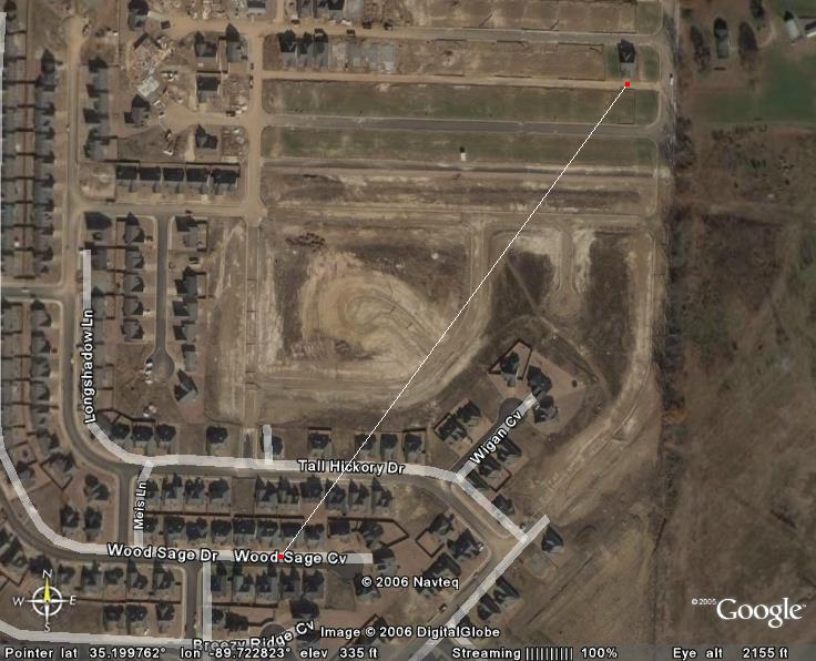
A brief F1 tornado touched down yesterday in the Franklin Farm subdivision near Lakeland, TN. According to a Public Information Statement from the NWS in Memphis, the tornado "touched down near Wood Sage Cove ... around 6:35 PM CDT." It then continued across Tall Hickory Drive and lifted back into the air. The path length was 500 yards. Here is one picture (thanks Google Earth) showing the upclose path of this tornado (click for larger version).

In addition to this map, I have also made an image of the track in relation to the Wolfchase Galleria area, for those not familiar with this area (click for larger version; look for white line with red dots).

According to the Local Storm Report, about 20 homes were damaged, and luckily, there were no injuries. However, a few homes had significant roof damage and one SUV had windows blown out of it.

The initial reports of this tornado came from local broadcast media. WPTY has a more detailed story on some damage. Look for more stories on this tornado from the local media in the days to come.

This week is Lightning Safety Awareness Week

Yes, the title says it all. June 18-24, 2006 is the official Lightning Safety Awareness Week from the National Weather Service. Each day this week, we will show you some different aspects of lightning safety, ranging from "The Medical Aspects of Lightning" to "Lightning Safety Outdoors". We will bring you the unedited article from the NWS.

If you want to get a head start on this week, go to http://www.lightningsafety.noaa.gov for all kinds of information on lightning.

Slight risk of severe weather today

According to the SPC, most of the Mid-South is under a slight risk for severe weather today. "Locally damaging winds should be the main threat with these storms." Our local NWS office says that the most likely time for this severe weather will be 10 AM-10 PM. They also say that the heavy rain produced by these storms may result in some flash flooding. Then, they end with this note - "Spotter activation may become necessary today into this evening."

I'll do a technical analysis of this situation this afternoon. Stay tuned for more information.

Saturday, June 17, 2006

Weather station back online

UPDATE: Well, the station has gone offline again. Will look at it again tomorrow when it is daylight and not raining.

ORIGINAL POST (2:53 PM CDT): Yea! Finally, after a month of downtime, my weather station is back online. You can view the data at Weather Underground, CWOP, or AWEKAS. The links to these websites are on the sidebar at the right.

Monday, June 12, 2006

TS Alberto Links

As Alberto bears down on the Florida panhandle, I figured I'd create a link directory of related links. I do not warrant any of the info contained on these pages nor do I warrant it. If any of these links have objectionable content on them, please post a comment and I will remove it.

National Hurricane Center Info
Homepage
Latest Public Advisory
3 Day Forecast Map

Weather Underground
Tropical Homepage
Tracking Map
Computer Models
Alberto Radar

Tampa Television
WTVT - 13 (FOX)
WFLA - 8 (NBC) [WeatherPlus Live Stream]
WTSP - 10 (CBS) [Live Radar Stream]
WFTS - 28 (ABC)

Tallahassee Television
WCTV - 6 (CBS)
WTWC - 40 (NBC)
WTXL (under construction)

Orlando Television
WESH - 2 (NBC) [WeatherPlus Live Stream]
WKMG - 6 (CBS)
WFTV - 9 (ABC)
WOFL - 35 (FOX)

Florida Government Information
Florida EMA
Shelter Info

If you have any links to add, please post a comment and I will add it!

Syndication


[What is this?]

NEW: Simply click on the link below to add this content to anything you could possibly imagine.

Add to any service

Legal Information

© 2005-2007 by Jake Hughes. Some rights reserved - see below.

Creative Commons License

This work is licensed under a Creative Commons Attribution-Noncommercial-No Derivative Works 2.5 License.

Never base important decisions on this or any weather information obtained from the Internet.

All other trademarks and copyrighted material not mentioned here are the property of their respective owners.