Monday, May 29, 2006

More popcorn showers this afternoon

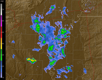
NWS radar is showing scattered showers in NE MS, north of Dyersburg, and in the MO Bootheel this afternoon. These are moving N at 10-15 mph (according to the NWS). Most of the storms will dump less than .5 in/hour, but some could dump over 1 in/hour. Some of the storms are strong with max hail sizes in the .75-1 in range. Max echo tops are 47200 kft.

One concern I have right now is a cell that is moving into Hardeman/McNairy Counties from MS. At 5:15, there seemed to be an area of possible rotation right over the town of Middleton. I will be watching this one closely. Also getting some high cloud tops with this one - 48900 kft. VIL is at 51 & max hail size is 1.12 in. I would not be surprised to see a warning out for this one soon.

Rain moving in this morning

Right now, there is a large patch of showers in southeastern Arkansas. These showers are generally light in nature, but there could be a few downpours located in this area. These showers are moving NNW at 25 mph.

For the rest of today, there is a 50% chance of showers. According to WU, most of these should move in after 11:00 AM, but the chances get higher as the day goes on. Tomorrow is the same situation.

Another update will come this afternoon.

Sunday, May 28, 2006

Scattered severe activity this afternoon

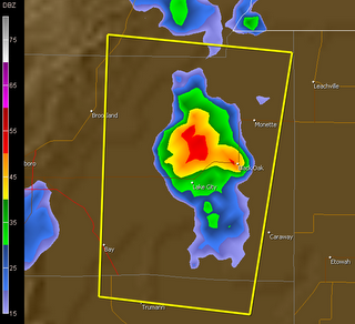
Well, those popcorn showers are kind of turning severe. There is a Severe T'storm Warning in effect for Craighead Co. in effect until 5:45. This storm is capable of producing nickel-sized hail and winds in excess of 60 mph. Here is an image from 5:16 PM (thanks to GR2):

This storm does not seem to be very impressive. No storm reports prompted the warning. The echo tops are only about 35 kft right now. This storm has weakened considerably and I bet that the NWS cancels this one early.

UPDATE: How did I know? The NWS has cancelled this warning as of 5:35 PM.

Afternoon Weather Update

Looking at the awesome software of GRLevel2 Analyst Version, many popcorn showers are developing across eastern Arkansas, with a few sprinkles over the rest of the Memphis CWA. Apparently, the NWS is somewhat fearful of these showers (Short Term Forecast):
IF A THUNDERSTORM OCCURS IN YOUR AREA...SEEK SHELTER INSIDE UNTIL THE STORM PASSES DUE TO THE OCCURRENCE OF DANGEROUS LIGHTNING.
Well, I guess this is true. Yesterday, a person at Pickwick Lake, near the TVA dam, was struck by lightning around 1:30 PM. The person complained of no feeling in his arm and the inability to swallow. He lived, though.

Today will the last day in the 90s for a while. Most of the week's highs seem to be in the mid 80s. Friday, however, it should creep back up to 90.

Hi! I'm back!

Howdy everyone! After a long hiatus, I decided to return to Blogger. I really don't know why, but I just feel like it.

Let me review you on what has happened to me in the past two months. I have met with Jim Belles at the National Weather Service twice, one time just to meet him and another time to discuss SKYWARN matters. By the way, I now have my amateur radio license: it is KI4PCT. I don't have a radio yet, but plan on getting one soon. I do, however, have EchoLink.

Also, my weather station is currently down. A few weeks ago, as some roofers were hard at work nailing shingles to our house, somehow they damaged my anemometer located on the roof. So, the data will be gone until I can purchase a new anemometer.

Much more has happened since then, but I've forgotten it. Oh well.

Jake

Syndication


[What is this?]

NEW: Simply click on the link below to add this content to anything you could possibly imagine.

Add to any service

Legal Information

© 2005-2007 by Jake Hughes. Some rights reserved - see below.

Creative Commons License

This work is licensed under a Creative Commons Attribution-Noncommercial-No Derivative Works 2.5 License.

Never base important decisions on this or any weather information obtained from the Internet.

All other trademarks and copyrighted material not mentioned here are the property of their respective owners.